18.07.2023
Press Release
Arable soils are a valuable resource for our food and biodiversity - and are at risk from drought, storms and heavy rainfall. To help farmers better protect their fields from erosion, the Leibniz Centre for Agricultural Landscape Research (ZALF), in cooperation with the Bavarian State Research Centre for Agriculture (LfL), has produced erosion maps that identify areas particularly at risk of erosion and thus help to target protective measures where they will have the greatest effect.
As with the recent heavy rains caused by Storm Lambert, farmers seem powerless in the face of increasingly severe weather events. Fields are flooded and fertile topsoil simply washed away. It is not just the harvest that is at risk: the eroded soil often ends up in watercourses. In the worst cases, this can lead to contamination or fish mortality due to lack of oxygen. What can farmers do to protect their harvests and at the same time better conserve biodiversity on land and in water?
Preserving biodiversity with the help of digitization
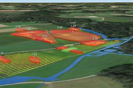
After a year of research, the EROSPOT project is providing high-resolution erosion maps to help farmers and advisers plan and implement measures to reduce soil erosion and run-off into surface waters. The main aim is to locate erosion-prone areas in the field to within a metre, and implement the necessary erosion control measures. "EROSPOT uses the latest geo-information technology to produce a map that makes it easy to see where something urgently needs to be done about erosion," says
Prof. Sonoko Bellingrath-Kimura, project leader at ZALF. Possible measures include the creation of green strips, flower strips or "beetle banks" that cross the water's path and thus reduce erosion. The aim is to preserve the soil in the long term and improve the quality of surface water. By promoting biodiversity and ecosystems through digitisation, the project fulfils a key objective of the DAKIS project, coordinated by ZALF, which helped fund EROSPOT.
Measures to combat soil erosion must be easy to implement
The focus is on minimizing additional burden on farmers. "We know that everyone has to think economically. Every extra tractor ride costs time and money. That's why the measures should be as easily compatible as possible with normal field work," says
Marvin Melzer, project coordinator and contact person for the data processing behind the tool. To achieve this, the project team's next step is to expand the data set to include lane analysis in conjunction with slope. This will make it easier to see, for example, where to change the direction of ploughing to reduce erosion, or where to best integrate a green area into the field. Farmers can transfer the suggested measures to their GPS-controlled tractors and manage the land in a targeted way. In the future, they will also be able to see the success of the measure on the erosion map.
In the long term, the data is to be available nationwide
So far, erosion maps of individual areas are displayed in a 3D web application. Before the end of this year, the data set will be extended to the entire state of Bavaria. Data for individual areas are already available on request. In the long term, the data on erosion-prone farmland will be freely available throughout Germany.
 Press Release as PDF
Project partner:
-
Leibniz Centre for Agricultural Landscape Research (ZALF)
-
Bayerische Landesanstalt für Landwirtschaft (LfL)
Funding:
The EROSPOT project is funded by the Bavarian State Ministry of Food, Agriculture and Forestry (funding code: A/22/01) and by the BMBF funding line "Agricultural Systems of the Future", project DAKIS (Digital Agricultural Knowledge and Information System), funding code: 031B0729A.
Further information:

