05.02.2025
Press Release
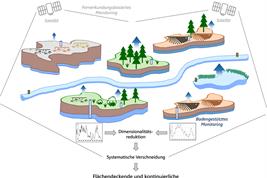
Efficient water management in human-dominated landscapes such as the mining region of Lower Lusatia requires a comprehensive understanding of the regional water balance. In a recent study published in the journal Hydrological Processes, scientists from the Leibniz Centre for Agricultural Landscape Research (ZALF) have developed a data-based method that makes spatial and temporal changes in water resources visible. The research shows how natural influences such as seasonal fluctuations in precipitation and evapotranspiration as well as human interventions such as lignite mining and land use affect the region's water balance.
Lusatia in north-eastern Germany has been changed by opencast lignite mining for decades. In addition to groundwater lowering, flooding of former open-cast mines has also led to a reorganization of the water balance. The landscape in Lusatia is also shaped by intensive agricultural use. From 1993 to 2022, the researchers collected over 1,800 data series on groundwater levels, surface water and runoff. They combined these with satellite data recording evapotranspiration and land use changes.
Using a statistical method known as principal component analysis, the researchers were able to identify the most important factors influencing the water balance. "We were able to show that changes in the water balance in Lusatia due to human intervention such as mining and other land use play a role," explains Jenny Kröcher from ZALF, the lead author of the study. "But natural processes, such as the severe drying out, especially in recent years, have also had a formative influence on the water balance." Even if it was not the subject of this study, it can be assumed that lowering of the groundwater level resulted in the destruction of wetlands with their typical flora and fauna. On the other hand, the flooding of former open-cast mines is often accompanied by severe acidification.
Maps make regional differences visible
A special feature of the work is the creation of maps that illustrate for the first time in detail how the various influences differ from region to region. For example, the researchers were able to show how large-scale groundwater lowering caused by mining affected neighbouring ecosystems over decades. As the availability of water for plants decreases, the seasonal patterns of evapotranspiration in the immediate vicinity of opencast lignite mines change. For example, the researchers observed less evapotranspiration in summer. As a result, plants are increasingly suffering from drought stress, which inhibits their growth and leads to a change in species composition in the region.
The maps also show how climatic changes over the last 30 years have affected the change in evapotranspiration for different land uses. For example, evapotranspiration on agricultural land is increasingly shifting to early summer and decreasing from July onwards. Particularly in dry years, such as between 2018 and 2023, the low water availability in the soil leads to an earlier collapse of evapotranspiration on agricultural land than in forests, which can benefit from a deeper root system and higher water retention in the soil. As a result, agricultural crops increasingly suffer from a lack of water in the summer months, which inhibits plant growth, reduces yields and increases susceptibility to heat stress.
"Our analyses provide an important basis for improving water management in such complex regions. This is becoming increasingly important, especially against the backdrop of climate change," adds Prof. Gunnar Lischeid, co-author of the study.
As a result of climate change, more extreme weather events such as droughts and heavy rainfall are to be expected. These not only affect the availability of water but also exacerbate existing problems in the region. Sustainable management of the water balance is therefore crucial to secure both human waters use and the protection of ecosystems in the long term.
Important findings for practice
The research results are not only scientifically relevant but also have practical significance: they can be used in the planning of measures for the renaturation of landscapes and adaptation to climate change. "The findings can help authorities and planners to protect water resources in a targeted manner while taking human uses into account," Kröcher emphasizes.
Project partners:
- Leibniz Centre for Agricultural Landscape Research (ZALF)
- University of Potsdam, Institute for Environmental Sciences and Geography
- Humboldt-Universität zu Berlin, Institute of Geography
Funding information:
The research project Monitoring of landscape surfaces and biodiversity using drone and satellite data in the Lusatia model region is part of the Land-Innovation-Lusatia alliance and was supported by the Federal Ministry of Education and Research (BMBF) under funding number 03WIR3020B.
Further information:
To the original publication: https://doi.org/10.1002/hyp.70053
Note on the text:
This is a summary of the original text created with the help of artificial intelligence: Kröcher, J., Ghazaryan, G., & Lischeid, G. (2025). Unraveling Regional Water Balance Dynamics in Anthropogenically Shaped Lowlands: A Data-Driven Approach. Hydrological Processes. DOI: 10.1002/hyp.70053, published Open Access under the license CC BY 4.0 https://creativecommons.org/licenses/by/4.0/. The text has been carefully reviewed and revised under the aspects of AI regulations at ZALF.

