21.03.2024
The dataset contains two kinds of wind-related-data for the site Forst (Lower Lusatia) in the SIGNAL project. The relative wind speed was simulated with the Large Eddy Simulation model ASAM (All Scale Atmospheric Model, Jähn et al. (2015).
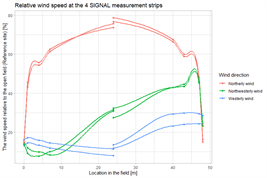
The relative wind speed was calculated for three different wind directions (N, NW, W), for a tree height of 5 m and at a height of 0.5 m above ground. Potential erosion risk in this dataset is defined as wind speeds above 5m/s at 0.5m height above the ground. In total, the dataset contained 742 days of at least one 30 min maximum wind speed measurement. Each wind speed above 5m/s, is considered as a potential erosion risk event. A maximum wind speed larger 5m/s per day is considered as potential erosion risk. The number of days with potential erosion risk was summed for each measurement point.
Download this data set:
https://doi.org/10.20387/bonares-gnhx-qthg
You can also upload your data here:
https://upload.bonares.de

