21.02.2025
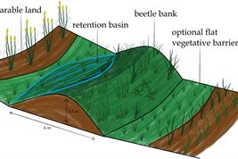
A narrow earthen ridge on sloping farmland can help protect fields from soil erosion – if placed correctly. These so-called beetle banks are about half a metre high and are typically planted with native wildflowers and grasses. In addition to slowing surface water runoff, they provide habitat for beneficial insects such as ground beetles. However, their effectiveness depends on precise placement within the landscape. Researchers at the Leibniz Centre for Agricultural Landscape Research (ZALF) have now developed a digital planning tool that identifies locations where beetle banks provide the greatest benefits. The model-based results are now set to be implemented in practice for the first time: Beetle banks will be installed on a test site in Bavaria this year, where their effectiveness will be evaluated.
Beetle banks are placed perpendicular to the slope to retain water, reduce erosion, and create habitats for insects. The research findings show that their effectiveness strongly depends on placement. If positioned incorrectly, they may even accelerate erosion. The new digital tool was developed as part of the Digital Agricultural Knowledge and Information System (DAKIS) project. It not only analyzes terrain conditions but also considers machinery track planning and operational constraints.
The tool introduces two key innovations for agricultural practice
One major advancement is the integration of track planning with a detailed terrain model. Until now, farm management software has primarily optimized machinery tracks based on field shape and boundaries to save time and fuel. However, slope inclination is often ignored, even though machinery tracks running parallel to a slope can increase erosion. The new model incorporates high-resolution digital elevation data (1-meter resolution) and suggests contour-aligned tracks where practical farming requirements allow.
Additionally, the method enables the targeted integration of beetle banks as a conservation measure. Existing models typically place agri-environmental features, such as wildflower or erosion control strips, only along field edges. However, beetle banks need to be located within the field, which can create obstacles for machinery. The model calculates how beetle banks can be integrated into track planning, ensuring they can be bypassed while effectively reducing runoff. A topographic profile analysis identifies locations where beetle banks can retain water without causing unwanted waterlogging or erosion risks.
Researchers hope this approach will also provide wider benefits for landscape-scale water management. “During heavy rainfall, water should remain on the fields longer and later be available to crops. This could reduce nutrient and pesticide runoff into water bodies and help protect settlements from flooding,” explains
Marvin Melzer, lead author of the study at ZALF and researcher in the DAKIS project.
Simulated water runoff – placement is critical to success
The study modeled how different beetle bank heights (40 cm and 50 cm) influence water runoff in the landscape. The simulation confirmed that well-planned beetle banks effectively redirect runoff, protecting downslope arable land from erosion.
“The new method could be integrated into track planning software used by major agricultural machinery manufacturers. This would give farmers a tool that combines track planning, erosion control, and biodiversity conservation—without adding significant management effort,” says Marvin Melzer.
Next step: Practical implementation
So far, the study results are based on simulations, but practical implementation is now planned. During the second funding phase of the DAKIS project (DAKIS2), the digital method will be tested on real farmland for the first time. In Bavaria, in collaboration with the Bavarian State Research Center for Agriculture (LfL) and local farmers, beetle banks will be installed at locations determined by the model calculations. The researchers will investigate whether digital planning achieves the expected benefits for water retention and erosion control, as well as how these measures can be integrated into long-term farm management practices.
Funding opportunities for farmers
The digital tool could help link agricultural subsidies more closely to ecologically effective measures. Currently, many agri-environmental programs reward conservation efforts primarily based on area size, without fully considering their actual ecological impact. While beetle banks are already eligible for agri-environmental and climate measures (AECM) in some regions, such as Bavaria, funding policies in Germany vary by federal state. Some programs support erosion control measures or the promotion of beneficial insects, but there is currently no dedicated subsidy for beetle banks. The new model identifies where beetle banks have the greatest impact on erosion control, water retention, and biodiversity. This could help ensure that future subsidies are allocated to measurably effective conservation measures, providing targeted support for farmers implementing sustainable practices.
Project partner:
- Leibniz Centre for Agricultural Landscape Research (ZALF)
- Bavarian State Research Centre for Agriculture (LfL)
Funding:
This work was carried out as part of the Digital Agricultural Knowledge and Information System (DAKIS, funding code: FKZ 031B0729A) project funded by the German Federal Ministry of Education and Research (BMBF). Olivia Spykman's contribution was funded by the Bavarian State Ministry of Food, Agriculture, Forestry and Tourism (grant number A/21/17).
Text disclaimer
This is a summary of the original text created with the help of artificial intelligence: Melzer, M., Spykman, O., Bellingrath-Kimura, S. (2025). Beetle bank-positioning on sloped farmland to promote water retention and biodiversity in farm management information systems for agri-environmental schemes. Biological Conservation, 302, 110999.
https://doi.org/10.1016/j.biocon.2025.110999, published Open Access under the license CC BY 4.0:
https://creativecommons.org/licenses/by/4.0/.
The text has been carefully reviewed and revised in the light of AI regulations at ZALF.
Further Information: