23.01.2024
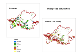
This data set contains information about main tree species in 1780 and 1890 derived from different sources.
Geodata base is the hand drawn Schmettau Map (1:50.000, ca. 1780) and the Prussian Land Survey (scale 1:25.000, ca. 1890). Additional information from other sources where aligned and added. In total about 200 maps and the same number of archival documents where checked for reconstruction of spatial explicit tree species localities. This table contains the index of all tables forming this data collection. Related datasets are listed in the metadata element 'Related Identifier'.
Download this data set:
https://doi.org/10.4228/zalf-qwhz-e977
You can also upload your data here:
https://upload.bonares.de